Research Interests
Use of Non-Destructive Technologies for Civil Infrastructure Health Monitoring
Keywords: Ground Penetrating Radar (GPR), Machine Learning Algorithm, Pavement Structural Deterioration
Details
Our group has established a Ground Penetrating Radar (GPR) System to look beneath the surface of roadways in a non-invasive manner at a highway speed (65 mph) and assess their condition beyond what the naked eye can see. With a developed machine learning algorithm, Kim lab group uses the scanned GPR data: 1) to detect sinkhole potential and 2) to predict the potential pavement structural deterioration due to the weak pavement foundation.

Remote Sensing Applications for Road Condition Monitoring by Means of Multispectral Satellite Imagery
Keywords: Pavement Monitoring, Remote Sensing, Multispectral Imagery, Machine Learning, Predictive Maintenance
Details
Our lab leads cutting-edge advancements in pavement monitoring, vital for the socio-economic fabric of nations. Traditional methods, like PCI and IRI, have resource-intensive constraints. We’re leveraging remote sensing technology. Remote sensing captures data through electromagnetic radiation across the spectrum. In pavement engineering, we employ multispectral imagery, offering wide bandwidth and long-range capabilities. However, precision remains a challenge due to mixed pixel issues. To address this, we integrate machine learning with remote sensing. Using satellite data, our algorithms automate pavement condition analysis, streamlining predictive maintenance. In preliminary research, we analyzed concrete and asphalt pavements with multispectral and hyperspectral imaging. Concrete pavements showed consistently higher reflectance. Satellite imagery detects maintenance interventions, and hyperspectral scans reveal aging asphalt’s spectral changes due to traffic. Join us in advancing pavement monitoring for safer, cost-effective roadways.

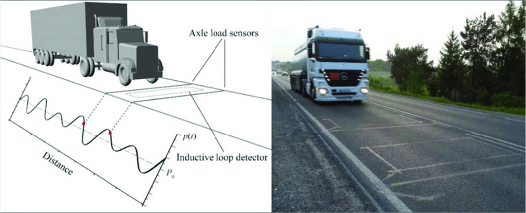
Investigation of Heavier-Than-Expected Vehicle Weights Observed in the Vicinity of the Savannah Port Area and Their Impact on Georgia’s Pavements and Bridges and Rate of Statewide Asset Degradation
Keywords: Heavy Vehicle Weight, Pavement Degradation Prediction, Bridge Degradation Prediction
Details
The Port of Savannah is one of the busiest maritime hubs in the U.S., experiencing escalating container capacity, which has put significant strain on local infrastructure. The research aims to quantify the impact of heavy vehicle traffic on pavements and bridges. Further, it seeks to assess the frequency of over-limit vehicles throughout Georgia, beyond just the port traffic. Weigh-in-Motion (WIM) technology will be utilized to gather the requisite data.
Researches on Mechanistic-Empirical Pavement Design Guide
Keywords: Sustainable Pavement Materials, Mechanistic-Empirical Pavement Design (MEPDG) Manual, Forensic Analysis of Damaged Pavement, State Highway Agencies
Details
Kim lab group has pursued researches to directly advance the art of sustainable pavement materials, design and maintenance. The area of Kim lab research is, but not limited to, in research and testing of pavement materials such as asphalt concrete, Portland cement concrete, aggregates, and soils to create truly sustainable pavements to build roadways at optimal costs. Dr. Kim has been a PI or Co-PI on numerous awarded external grants in this area. Based on the pavement researches funded by GDOT, Kim lab group has compiled all the pavement research outcomes into the GDOT Mechanistic-Empirical Pavement Design (MEPDG) Manual. In this design manual, Kim lab group provided guidance and recommendations to the Georgia engineers for utilizing the new MEPDG to more accurately design pavement structure and evaluate pavement performance. Kim lab group also developed a set of guidelines for the forensic analysis of damaged pavement that outline best methods for pavement repair and replacement for roadways. This step-by-step analysis enables the state highway agencies to identify problems early, fix the pavement distresses, and avoid costly delays.

Climate Resilient Natural Infrastructure – Funded by NSF/USDA NIFA
Keywords: Sea Level Rise, Soil Organic Carbon, Salt Marsh Resilience
Details
As sea level slowly rises, many marshes can enhance C sequestration through sediment trapping and soil organic carbon (SOC) accumulation. SOC, often measured generally by proxy of soil organic matter (SOM), is a key parameter reflecting marsh accretion. With increasing rates of sea-level rise, some marshes have been unable to respond adequately, and the marsh platform becomes unstable; this phenomenon is projected to lead to reduced primary productivity, increased erosion, and eventually, mineralization of the stored SOM. Surface and belowground SOM is a critical soil property to salt marsh resilience. Surface and belowground SOM data in salt marshes obtained through remotely and continuous data collection in conjunction with field observations and predictions from machine learning (ML) algorithms will provide insight into the challenges faced by salt marsh research groups.
